
Mount Saint Helens Classic - Event Information
Background
The Mount Saint Helens Classic (MSHC) is a stage swim race on four lakes in the southern Cascade Mountains of Washington State surrounding Mount Saint Helens – a 40,000 years young stratovolcano best known for its catastrophic eruption in 1980 which shaved a quarter-mile of rock off the peak. If you’ve heard of SCAR Swim in Arizona, well this swim is a lot like that, but with the much nicer summer weather of Washington State and pines instead of cacti.
Should you choose to swim all four lakes, the MSHC swim is just over 37 miles spanning 4 consecutive days. At this time of year, the weather and water should still be warm, and the summer boating season will be wrapping up. Not to jinx anything, but there aren’t many places on earth nicer than the Pacific Northwest in early September. Each swimmer will be required to have a kayaker with them through the swim and additional powered safety boats will patrol the course.
To complete all 4 swims is a very serious endeavor, and athletes should be well prepared. This is not a swim for beginners. While all swims are intended to take advantage of prevailing winds, the weather in the Pacific Northwest is predictable only in being unpredictable and weather in the mountains can change rapidly. The rules for the swims follow those of standard NOWSA solo marathon swims (a Rules supplement is forthcoming with some event-specific clarifications). This means standard swimming attire, no wet suits, single swim cap, no hanging onto the kayak, etc. It is a solo swim, it is meant to be a challenge…but also very, very fun.
specifics
We’ve tried to anticipate what questions you may have, and have answered those on our FAQ page →
If you can’t find the info you need, or have more questions, send a message to Race Director Eric Durban →
Now, let’s meet the lakes…
Stage 1: Riffe Lake + 13.0 miles

The most remote of all the lakes, it is also the longest of the swims. This lake is also on the Cowlitz River, upstream from Mayfield Lake and is located behind Mossyrock Dam, which was constructed between 1965 and 1968 and is the tallest in Washington state at 606-ft. In 2017, the water levels were lowered 30 feet due to seismic safety concerns. The lower water levels have significantly reduced boat traffic at the east end of the lake due to the closure of the Taidnapam Boat launch. Other than Mossyrock Park at the west end of the lake there is almost no development on the lake.
Swimmers will have a dry start adjacent to the swimming area near the boat launch at Mossyrock Park and proceed along the southeast to the finish at the Dog Mountain Landing Zone. There will be 3 course buoys roughly 4 miles apart that swimmers must pass on their left shoulder. Water temperature on a test swim in mid-July 2024 was 74-77F.
STAGe 2: Mayfield Lake + 7.2 miles
This is a perfect warm-up swim, and the shortest of the stages. The lake is located on the North side of Mount St Helens on the Cowlitz River. The lake was created by the Mayfield Dam, a 250-ft high concrete arch and gravity dam constructed in 1963 which generates electricity for the city of Tacoma, WA. With fish hatcheries and a few rustic resorts on its shores, it is still a largely unpopulated lake. But does it have a lighthouse? Of course it does. Why? Unclear.
The swim starts on a small beach on the north side of the lake and proceeds east for about a ¾ of a mile before crossing the lake and heading west then south down the lake. There are two course buoys which must be passed on each swimmer’s right shoulder. The finish is on the beach at the Mayfield Lake Resort. Water temperature on a test swim in mid-July 2024 was 72-75F.

Stage 3: Lake Merwin + 10.5 miles
South of Mount Saint Helens on the Lewis River sits our third lake. Lake Merwin was created by the construction of the 313-foot tall Merwin Dam between 1929 and 1931. The dam sits in the town of Ariel, and may have been the area in which DB Cooper jumped from a hijacked airplane with $200k of ransom money in 1971.
The Lake Merwin swim will be a buoy course starting at Speelyai Bay Park swim area. The swim will proceed south out into the main body of water and turn west for roughly 3 miles staying to the right of 2 course buoys. After passing the second course buoy, swimmers will cross the lake to a 3rd course buoy – again staying to the right before turning east. There are two additional course buoys along the south shore that each swimmer must stay to the right of as well. The finish line is immediately after passing under the Yale Bridge at the foot of metal staircase that goes up the right (south) shore to the bridge level. This swim is expected to have the most boat traffic.

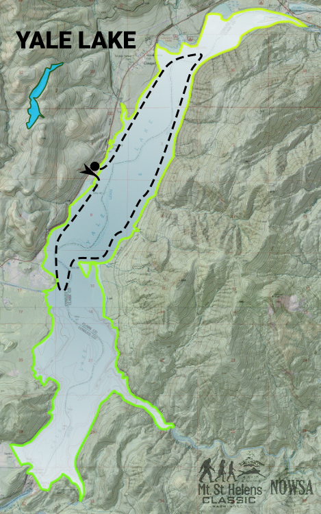
Stage 4: Yale Lake + 8 miles
In our opinion, the most scenic of the lakes is Yale Lake. The view of Mount Saint Helens from the water is magnificent. Yale lake sits just upstream of Lake Merwin on the Lewis River, and was formed in 1953 with the construction of Yale Dam for hydroelectric power. Since 2020, the lake levels have been kept at least 10-ft below maximum due to seismic concerns.
The start of the swim will be from the Yale Park boat ramp midway down the lake on the western shore. It is roughly a rectangular course, with swimmers swimming south on the western shore for just under 2 miles before rounding a course buoy and swimming northeast to the eastern shore. Course buoys are located at 3.5 miles and 5.5 miles which swimmers must stay to the right of. At the 5.5 mile course buoy the swimmers will cross the lake to the western shore and then south back to Yale Lake Park. Depending on water levels on the lake, care should be taken to avoid submerged stumps along the western shore. Swimmers may observe these before their kayakers do. The finish line will be at a buoy just offshore from the Yale Park boat ramp. Water temperatures on a test swim in mid-July 2024 was 72-75F.